


Union Valley Voting District, Perry County, Arkansas
About
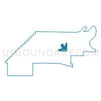
Outline

Summary
| Unique Area Identifier | 527539 |
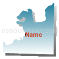
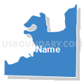
| Name | Union Valley Voting District |
| County | Perry County |
| State | Arkansas |
| Area (square miles) | 9.14 |
| Land Area (square miles) | 8.90 |
| Water Area (square miles) | 0.25 |
| % of Land Area | 97.32 |
| % of Water Area | 2.68 |
| Latitude of the Internal Point | 34.96341560 |
| Longtitude of the Internal Point | -92.81612470 |
Maps


Graphs
Select a template below for downloading or customizing gragh for Union Valley Voting District, Perry County, Arkansas


Neighbors
Neighoring Voting District (by Name) Neighboring Voting District on the Map
- Cherry Hill Voting District, Perry County, AR
- Fourche La Fave Voting District, Perry County, AR
- Maumelle Voting District, Perry County, AR
- Perryville Ward 2 Voting District, Perry County, AR
- Perryville Ward 3 Voting District, Perry County, AR
- Rankin Voting District, Perry County, AR
Top 10 Neighboring County Subdivision (by Population) Neighboring County Subdivision on the Map
- Fourche Lafave township, Perry County, AR (1,796)
- Rankin township, Perry County, AR (1,296)
- Maumelle township, Perry County, AR (476)
- Union Valley township, Perry County, AR (352)
- Cherry Hill township, Perry County, AR (265)